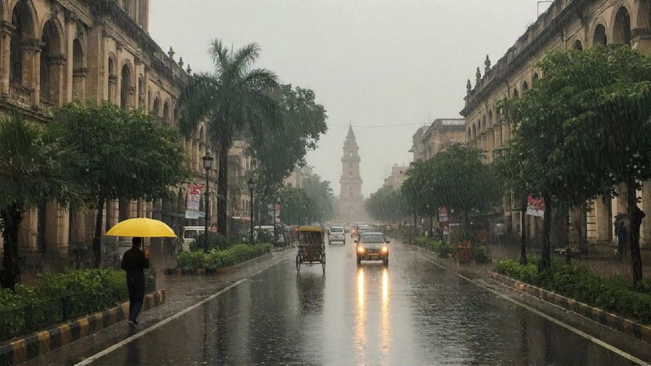
When India Meteorological Department issued its alert on October 28, 2025, at 1:45 p.m. IST, it wasn’t just another weather bulletin — it was a warning that Cyclone Montha had transformed from a disturbance into a severe cyclonic storm, threatening lives, crops, and infrastructure across 15 states. The storm, churning in the southeast Bay of Bengal, was barreling toward the Andhra Pradesh coast with wind speeds of 90–100 km/h and gusts up to 110 km/h, expected to make landfall near Kakinada by Monday night. But the real damage wasn’t just at the coast. Rainfall, thunderstorms, and sudden temperature drops were already rippling hundreds of kilometers inland — from Rajasthan to Bihar, from Uttar Pradesh to Kerala. And for farmers already reeling from last month’s floods, this was the last thing they needed.
Storm’s Reach: From Coastal Andhra to the Thar Desert
The India Meteorological Department didn’t mince words. Isolated very heavy rainfall was forecast for Vidarbha and Saurashtra & Kutch. But the surprise? Rajasthan — a state synonymous with dry heat — was drowning. In Nainwa, Bundi district, nearly four inches of rain fell in just 24 hours. That’s more than what some parts of Rajasthan get in an entire October. Cities like Kota, Udaipur, and Chittorgarh saw daytime highs plunge to 21–22°C — a drop of 6–8°C below normal. In Kota, the temperature didn’t even rise above 21.9°C all day. Nighttime lows hovered at 21.6°C. It felt like early winter, not late October.
According to Easeweather.com, October 2025 in Rajasthan averaged 30.6°C — 2.6°C below seasonal norms. The IMD confirmed: unseasonal rain was the culprit. And the cost? Farmers in Udaipur, Pratapgarh, Kota, and Baran are facing ruin. Harvested crops — pulses, oilseeds, wheat — soaked in rain, rotting in fields. One farmer in Baran told local reporters, “We waited six months for this harvest. Now the grain’s wet, the market won’t take it, and the banks won’t give us loans again.”
Eastern India Braces for Deluge
While Rajasthan shivered, eastern India prepared for floods. The IMD warned of thunderstorms with gusts up to 50 km/h across Odisha, Bihar, and Jharkhand from October 29 to 31. Gangetic West Bengal and Telangana were also on high alert. In Patna, drainage systems — still clogged from last year’s monsoon — began overflowing by Tuesday morning. Schools in 12 districts suspended classes. Emergency teams were deployed along the Ganges and Kosi riverbanks.
Uttar Pradesh, too, was split. Eastern UP — districts like Ballia and Lucknow — faced persistent rain on October 27, 29, 30, 31, and November 1. Western UP, by contrast, stayed mostly dry. But even there, isolated thunderstorms popped up on the 28th. The state’s weather office noted wind speeds of 30–40 km/h, similar to last month’s conditions that flooded Mathura and Noida. “We’re seeing a pattern,” said senior meteorologist Dr. Anjali Mehta. “Cyclones aren’t just coastal events anymore. They’re pulling moisture deep inland, creating hybrid disasters.”
Why This Storm Is Different
Historically, October cyclones in the Bay of Bengal are rare. Most form in May–June or September–October, but rarely intensify this late. Cyclone Montha defied norms. Sea surface temperatures in the southeast Bay remained 2–3°C above average, thanks to lingering El Niño effects. Warm water = more fuel. And with low wind shear, the storm had a clear path to grow. By October 27, it had already outpaced last year’s Cyclone Biparjoy in intensity.
What’s worse? Infrastructure hasn’t caught up. Many rural roads in Odisha and Andhra Pradesh remain unpaved. Power lines, already brittle from monsoon damage, are now at risk of collapse. In Lakshadweep, 3,000 residents were evacuated from low-lying islands. Schools turned into shelters. The navy deployed two vessels for emergency supply runs.

What’s Next? Clear Skies, But Lasting Damage
The IMD predicts rainfall activity will taper off after October 30, with clear skies returning by November 2. But the damage? That won’t vanish so easily. Crop losses in Rajasthan alone are estimated at ₹1,800 crore. In Bihar, early paddy crops — already delayed by monsoon flooding — are now mold-infested. The Food Corporation of India has begun emergency procurement talks. Meanwhile, Delhi and nearby areas are bracing for light drizzle as the storm’s remnants drift north. Air quality, already poor, may worsen as dust mixes with wet particles.
Climate scientists warn this isn’t an anomaly — it’s a preview. Warmer oceans, shifting jet streams, and erratic monsoon patterns are turning once-rare cyclones into annual threats. “We used to say ‘cyclone season’ was June–November,” said Dr. Rajiv Menon, an atmospheric researcher at IIT Delhi. “Now, we’re just saying ‘cyclone season’ — period.”
Frequently Asked Questions
How is Cyclone Montha affecting farmers in Rajasthan?
Farmers in Udaipur, Kota, Pratapgarh, and Baran lost an estimated ₹1,800 crore in harvested crops due to unseasonal rainfall. Pulses, mustard, and wheat fields — already dried after a delayed monsoon — were soaked by up to four inches of rain in 24 hours. Wet grain spoils quickly, reducing market value by 40–60%. Many smallholders can’t afford drying equipment, forcing them to sell at steep discounts or discard harvests entirely.
Why is Rajasthan getting rain when it’s usually dry in October?
Cyclone Montha’s outer bands pulled moisture from the Bay of Bengal across central India, reaching as far west as Rajasthan. This is rare but not unprecedented — similar patterns occurred in 2018 and 2021. Warmer sea temperatures and weakened western disturbances have made such long-distance moisture transport more frequent. The IMD now classifies these as “remnant cyclone systems,” distinct from traditional monsoon rains.
Which districts are at highest risk of flooding?
The IMD has flagged 12 high-risk districts: Gangetic West Bengal (Murshidabad, Nadia), Bihar (Patna, Bhagalpur), Odisha (Koraput, Ganjam), Andhra Pradesh (Kakinada, East Godavari), and Uttar Pradesh (Ballia, Ghazipur). These areas have poor drainage, saturated soils from prior rainfall, and low-lying terrain. Emergency teams are on standby, and 37 relief camps have been opened across these districts as of October 29.
What’s the temperature drop in affected regions?
Daytime temperatures fell by 6–8°C across Rajasthan, Madhya Pradesh, and parts of Uttar Pradesh. Kota recorded a max of 21.9°C (down from 29°C last week), while Udaipur dropped from 31°C to 22.5°C. In Patna, highs fell from 34°C to 28°C. This sudden chill, coupled with humidity, has triggered respiratory issues — hospitals in Jaipur and Lucknow reported a 30% spike in asthma cases since October 26.
Is this linked to climate change?
Yes. Studies from IIT Bombay and the Indian Institute of Science show that Bay of Bengal cyclones are intensifying later in the year due to rising sea surface temperatures — up 0.5–1.2°C since 1990. Cyclone Montha is the fifth severe cyclone to form in October since 2018, compared to just two between 1980–2000. Experts say climate change is extending the cyclone season and increasing rainfall intensity by 15–20% per event.
When will the weather return to normal?
The IMD forecasts clear skies by November 2, with temperatures gradually rising back to seasonal norms. However, residual moisture may linger in eastern states until November 5. Air quality in Delhi and NCR is expected to improve as winds clear pollutants, but crop damage and infrastructure repairs will take weeks — if not months — to recover from. Emergency aid has been approved for 1.2 million affected households across five states.